

© Shipping Wonders of the World 2012-

The Panama Canal
The great artificial shipping lane separating North and South America is an unparalleled engineering triumph. Its construction cost about £75,000,000 and changed many of the world’s important trade routes

LOOKING SOUTH from the upper lock at Miraflores on the Panama Canal. The Canal, under the control of the United States of America, was opened in 1914 but did not come into regular use until 1916. It links the Atlantic and Pacific Oceans, and its length is 50·76 statute miles.
THE Panama Canal is one of the wonders of the world. It connects the Atlantic and Pacific Oceans by means of a waterway raised 85 feet above sea-
Within living memory the whole area has been transformed in a way that is little short of marvellous. Not long ago it was one of the most deadly regions in the world for white men; now it is one of the healthiest in the tropics and among the most interesting in the world. Both for commerce and for strategical reasons the Canal is of paramount importance. It was opened in 1914, but because of landslides in the Gaillard, or Culebra Cut, it was closed from time to time and was not in regular use until 1916. The largest ships in the world can pass through, among these having been the British battle cruiser H.M.S. Hood (42,100 tons).
Although the city of Panama is not on the Canal, it is near. The territory through which the Canal runs is called the Canal Zone and comprises a strip of land about ten miles wide crossing the Isthmus. This territory is administered by the United States through the Governor of the Panama Canal, and surrounds the two cities of Panama and Colon; but these cities, although partly under the administration of the Canal Zone, e.g. for sanitation and quarantine, belong to the republic of Panama.
Balboa is the Pacific gate of the Canal and adjoins Panama City, which has a harbour facing the Pacific and not connected with the Canal. On the Atlantic side the town of Colon is adjoined by Cristobal, which is in the Zone. Colon Harbour is sheltered by the breakwaters that protect Limon Bay and is administered by a Panaman harbour master; but this harbour is only for local craft, as Cristobal, administered by the Canal authorities, is the port of entry for the Canal.
The twin city of Cristobal Colon is somewhat confusing to the stranger, as part is under American and part under Panaman control During Prohibition one area was teetotal and the other was not, so that cafes and bars were sometimes situated on one side of a road only, the other side being “dry”.
Many people think of the Panama Canal as running from east to west, but this is not so. Cristobal Colon lies north-
The hilly nature of the country, and the dense tropical vegetation, are in sharp contrast to the great locks and their machinery, and make a passage through the Canal an impressive experience.
The approach from the Atlantic leads through the Caribbean Sea. Ships from the Atlantic seaboard of the United States and Canada, Europe, the Mediterranean and the Atlantic coast of South America pass between the east and west breakwaters. These have been built to protect Limon Bay from the strong northerly winds that blow across the Caribbean at certain seasons. Cristobal Colon lies south of the hurricane belt, but before the breakwaters were built a considerable swell set up by northerly winds used to roll into the harbour. The humidity is great, and at times it is difficult to pick up the land because of haze. After she has passed between the breakwaters the vessel steams south along the dredged channel.

A SCALE MAP of the Canal, showing its direction and locality. The territory through which the waterway runs is called the Canal Zone and consists of a strip of land some ten miles wide across the Isthmus. This Zone is administered by the United States Government ; but the cities of Panama and Colon, though partly under American administration, belong to the republic of Panama.
Colon is built on an isthmus the extreme end of which is Manzanillo Point; on the opposite side of the Point is Manzanillo Bay, a water playground for the “Zonites”, as the Americans employed by the Canal Commission like to call themselves. To port are seen the buildings along the water-
Eighty-
Colon was developed when the Panama Railroad was built, and was then called Aspinwall, after one of the officials of the railway. It became the port of transhipment on the Atlantic side. When the French arrived they altered the name to Colon, calling the docks section Cristobal, the full Spanish name, Cristobal Colon, being that of Christopher Columbus.
One of the first features to impress the traveller is the prevalence of wire screens; all doors and windows are protected by wire to keep out mosquitoes, and visitors are reminded of fly-
Leaving Cristobal, the vessel steams along the dredged channel to the head of Limon Bay and passes between low-

THE MOST DIFFICULT SECTION of the Panama Canal to construct was the Gaillard Cut. For nearly eight miles the Canal had to be driven through rock; landslides have frequently blocked this stretch. The Cut has to be continually dredged at night, and speed through it is restricted to six knots. This photograph of the Cut shows the S.S. Dramatist, of 5,443 gross tons, proceeding towards Gamboa and meeting the M.V. Theodore Roosevelt, of 5,614 gross tons.
These locks are the most impressive on the Canal. All the locks are in double section, and at Gatun there is therefore a total of six locks, each chamber being 1,000 feet long by 110 feet wide. The twin locks are divided by a massive centre wall, and each chamber is 70 feet deep, holds about 6,000,000 cubic feet of water, and uses 3,000,000 cubic feet for each filling. These sizes are standard for the Canal. Most chambers are divided into lengths of 600 feet and 400 feet so that, when small vessels are locked through, water can be saved.
The chambers are filled, not by pumps, but by admitting water from Gatun Lake at the summit of the 85-
Signals at the entrance to the locks indicate which set a vessel is to use. As there are two sets of locks, one set can be used by southbound vessels, and the other by ships going in the opposite direction. There are three main culverts under the walls of each lock, with other culverts branching from them, water being admitted to the chamber through the sides and through the floor.
The control house is placed between the upper locks and contains a model of the locks, 64 feet long, which shows every movement. The lock master telephones his instructions to the operator in the control house, who manipulates a lever on the control board. This lever, which is electrically operated, opens or shuts the valves of the culverts. When the valves are opened, water from the lake flows into the chamber and fills it. The chamber is emptied by closing the upper valves and opening the lower ones. The water rises at the rate of 3 feet a minute in each chamber. The average time taken to lift a vessel to the level of Gatun Lake is about an hour. The chambers are so large that more than one ship can pass through at a time.
There are two sets of gates, 50 feet apart, so that should one be damaged the other is effective. Each steel leaf of the gates is 65 feet wide, about 70 feet high and 7 feet thick, the lower part being hollow and air-

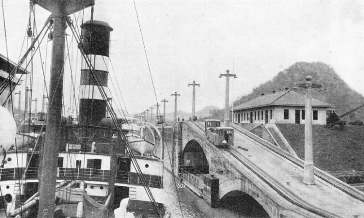
AT MIRAFLORES. A view of the two sets of locks which lower a southbound vessel 55 feet or so, according to the tide, to the waters of the Pacific. The lock walls here are 82 feet high, and the leaves of the gates weigh 730 tons. The posts seen along the lock side are lamp standards. Although transits through the Canal are generally made by day, navigation by night is possible.
In addition to the safety chains, each of which, made of 110-
The silence in which ships are “locked through” is impressive, almost the only sound being that of the mules. The locomotives climb a hump at the end of each chamber to reach the level of the one above it, and the impression is given that the ship is Gulliver being hauled along by the Lilliputians.
In the top lock the passenger, as he looks back towards Cristobal, has the thrill of seeing how high the ship has been raised above the Atlantic. The lake is pinned in by the lock gates and by the Gatun Dam. The dam, built of rock and earth, is half a mile wide at its base and 8,400 feet long. The spillway, with fourteen gates, discharges the surplus water of the lake into the Chagres River, which flows into the Atlantic to the west of Limon Bay.
Gatun Lake is fresh water, and the scenery on its banks is refreshing to the seafarer. The little town of Gatun lies on the port side as the vessel emerges into the lake and proceeds through the dredged channel. Speeds of between ten and fifteen knots are permitted. The lake widens out at Gatun, but ships keep to the channel, which crosses the lake for nearly twenty-
Through the Continental Divide
To port rise the towers of Darien radio station, marking the northern end of the reach. At Gamboa the Canal leaves the Chagres River bed to cross the divide by the Gaillard, or Culebra, Cut, the most difficult section to construct. The Chagres River lies to port at Gamboa, the signal station for ships in the Cut.
For nearly eight miles the Canal is cut through the rock, this section passing through the continental divide. The ground is so difficult that more than once the Canal has been blocked by landslides at this point. Water was let into the Cut in October, 1913, but a slide blocked it and the Canal was not opened to commerce until August 15, 1914. In September, 1915, a slide blocked the Canal until April, 1916.
At the south end of the Cut the divide opens out for the descent to the Pacific. The soil was found unsuitable for building one set of three series of locks, as at Gatun, and the difficulty was surmounted by building one step downwards at Pedro Miguel, and two steps a mile farther on at Miraflores.
The single pair of locks at Pedro Miguel takes the ship down some 30 feet, and she emerges into Miraflores Lake, the water of which is brackish because of the inflow of salt water from the locks at Miraflores. The two sets of locks at Miraflores lower the vessel 55 feet or so, according to the tide, to the waters of the Pacific.

PASSING THROUGH Miraflores Lock. This striking photograph shows the Rangitane (left) entering the lock from the Pacific side. The Rangitane is a vessel of 16,712 gross tons; she was built at Clydebank in 1929 for the New Zealand Shipping Company and has a length of 531 feet, a beam of 70 feet and a depth of 38 feet. She is passing a tanker belonging to the Standard Oil Company of California.
The average range of Pacific tide is 12½ feet, but the tide sometimes rises and falls 21 feet, and gates and walls of the lower lock are, therefore, the highest in the Canal. The lock walls are 82 feet high, and the leaves of the gates weigh 730 tons. The locks are built between two dams, the starboard dam, half a mile long, being of earth, on which are a few houses, and the dam to port being of concrete, with a spillway to release flood water. On the Atlantic side the tidal range is only a foot on the average.
The scenery from Miraflores is varied and interesting as the Pacific is approached. The tidal channel to deep water in Panama Bay is eight statute miles long, and for the first three miles the Canal follows the old valley of the Rio Grande. Military buildings crown the heights to port as the ship steams past Fort Clayton and Corozal.
Then comes the harbour called Balboa Basin, where ships berth. Sosa Hill is the signal station for pilots, and above this rises Ancon Hill, which separates Balboa, in the Zone, from Panama City, capital of the republic of Panama. Balboa has a dry dock 1,000 feet long, foundries, machine shops, piers and wharves.
Vessels proceeding to the Pacific pass through the dredged channel, leaving Balboa to port. After the coaling plant and oil tanks have been passed, Fort Amador is seen at the end of a spit of land.
From this runs a long causeway, with a road to connect three islands, Naos, Perico and Flamenco, so that the whole forms a breakwater, the length being about three miles. About half a mile south-
NORTHBOUND. This picture shows the S.S. Dramatist on her way from the Pacific to the Atlantic passing through the single pair of locks at Pedro Miguel. Ships do not pass through the locks of the Panama Canal under their own power, but are hauled by electric locomotives called mules. These locomotives -
On the starboard side the coast recedes. The dredged channel, which is well buoyed, ends near San Jose Rock, and about six miles from the end of the channel to the south is the conspicuous island of Taboga. Near it is the island of Taboguilla, with various smaller islands. Taboga is a holiday resort for the Canal employees, and a lighthouse off Taboguilla Island is one of the navigational marks leading to the entrance to the Canal. The average time of transit is about eight hours, although liners can make the passage in six, the expanse of Gatun Lake enabling the faster ships to accelerate. Speed in the Gaillard Cut, the two ocean channels and Miraflores Lake is restricted to six knots. Although navigation by night is possible, transits are generally made by day, and vessels intending to make the transit during the day of arrival are required to reach Balboa inner harbour by 2.45 p.m., and Cristobal inner harbour by 1.30 p.m. The dues are 1 dollar 20 cents (about 5s.) per net register ton for merchant ships carrying cargo or passengers, and 40 per cent less, or 72 cents (about 3s.) per ton for those in ballast. The fee for measuring a ship is 5 dollars (about £1).
At Balboa the atmosphere is less humid than at Cristobal, and the town has the advantage of adjoining Panama City. Canal employees shop at stores provided by the commissary and live in excellent quarters. For the amusements of a South American city they go across the way to Panama. As the sanitation and water supply are controlled by the Canal authorities, Panama combines the attractions of a Central American city with the hygiene of North America. It is a change from the stereotyped architecture of residential Balboa.
About five miles north-
The Isthmus of Panama became a vital line of communication soon after the Spaniards had reached the Pacific and had found the vast hoards of gold in the land of the Incas. The Andes were an impassable barrier, and treasure was taken to the Pacific coast, shipped to Panama, and then taken across the isthmus by the “road of gold”, as the track, was called, to Portobello, twenty miles from Cristobal, and sent in galleons to Spain.
When gold was found in California the early miners took ship to the mouth of the Chagres River at Fort San Lorenzo, went up that river as far as they could get to Las Cruces, now submerged by the waters of the Canal. Thence they struggled across the great divide to Panama, where they took ship to San Francisco and the goldfields. They were men in a hurry, and they did not want to waste time by going round Cape Horn.
This thirst for gold is one of the compelling urges of mankind, and when Panama became the treasure port of the Pacific its fame spread over the world. The first white men to cross the isthmus were the adventurers who followed Vasco Nunez de Balboa. He sighted the South Sea, as he called it, on September 25, 1513. Among the adventurers with him was Francisco Pizarro, the future conqueror of Peru. Balboa believed that there was a strait, and when explorers found none the idea of cutting a canal was discussed.
Cortes, conqueror of Mexico, suggested to the King of Spain in 1523 that a canal should be cut. Balboa got ships across in pieces at a high cost in life to the unfortunate natives. They were forced by their Spanish taskmasters to carry sections of brigantines from the Atlantic to the Pacific, where the vessels were put together.
The French Concession
After Magellan had found a way round South America by the strait that bears his name, the route was too long for the impatient Spaniards, and they drove a road from Old Panama to Las Cruces, on the Chagres River, down which treasure was taken in small craft to Nombre de Dios, and then, when the Spaniards abandoned that unhealthy spot, to Portobello. The gold was taken by road from Old Panama to Portobello, to be shipped to Spain.
The gold rush to California after the discovery of gold in 1849 attracted thousands of prospectors to the overland route. Steamships brought them from New York to the mouth of the Chagres River. They were then towed in canoes by natives up the river to a point near Las Cruces, which was as far as they could reach. They completed the journey on foot or on mules. The time taken was from five to ten days. Despite the fact that the prospectors often had to wait in Panama for a steamship to San Francisco, the route was much quicker than that round the Horn in a sailing ship. The calms of the Gulf of Panama made the route from there to California so tedious for sailing vessels that steamships were used, and the isthmus route thus gave an impetus to the development of the steamship.
About this time a railway was begun. After great difficulties it was completed, the first locomotive crossing the isthmus on January 27, 1855. There were various schemes for a ship canal, and a French company obtained a concession. This concern, La Compagnie Universelle du Canal Interoceanique de Panama, generally remembered as the Panama Canal Company, came under the direction of Ferdinand de Lesseps, who carried the Suez Canal project to success. De Lesseps was then past seventy. The French attempt failed, partly because of extravagance and corruption, and partly because of the terrible toll of fever. De Lesseps died in penury. Another company, the New Panama Canal Company, was formed in France and work was resumed, but the company was bought out by the United States in 1902. The Americans began occupation of the Zone in May, 1904.

UNDER WAY. The average time of transit of the Canal is about eight hours, although liners can make the passage in six. The dues are 1 dollar 20 cents (about 5s.) per net register ton for merchant ships carrying cargo or passengers, and forty per cent less per ton for those in ballast.
Any one who has spent some time in the Zone learns to respect the efforts made by the French engineers in their brave fight against the obstacles of the continental divide, the disease-
These French pioneers had no data to help them. When they arrived there was no adequate survey, nor was there any information about the supply or quality of labour: worst of all, they did not know that their deadliest enemy was the mosquito.
When the Americans took over the project they came armed with medical knowledge and experience of cleaning up tropical swamps. The researches of Dr. (afterwards Sir) Ronald Ross had established that malaria is spread by the female of certain mosquitoes (anopheline), and it was found that other diseases are spread in the same way.
The Americans built reservoirs to supply Panama City and the Zone with clean drinking water, and installed sewage systems. They rebuilt Colon and part of Panama City, screened houses with mosquito netting, eliminated standing water and sent squads of men into the jungle. These men worked in three divisions. The first division reduced the number of places in which the mosquito could lay eggs by draining swamps, cutting brushwood and burning grass. The second division attacked the larvae by spraying puddles and pools with larvicide. The third devised mosquito-
In the early days the Americans repaired and used some of the plant purchased from the French company; but, after the magnitude of the task had become known, new machinery was installed.
Gigantic Landslides
The Gaillard (Culebra) Cut was the most difficult of all. Human ingenuity and concrete had conquered the problems of the locks and the mighty dam at Gatun, but the Cut won again and again. The highest point to be excavated was 554 feet above sea-
So great was the pressure of part of the rock that the weight forced the softer earth into the Cut, or else the earth collapsed in ordinary landslides. The French engineers had worked on this for years. The Americans who followed have excavated more than 150 million cubic yards of material, half of which was landslides. The gigantic landslides of 1915 which blocked the Canal consisted of 12,000,000 cubic yards which had to be moved.
The Cut is dredged at night after traffic has ceased. The repair base for dredges and tugs is in Paraiso Reach, near the Pedro Miguel Locks. The equipment includes two giant cranes, either of which can lift 250 tons. There is a station where ships can berth at the south end of the Cut, on the east bank.
The headquarters of the Isthmian Canal Commission are at Balboa Heights. The Panama Railroad was bought by the Government and was reconstructed to aid the building of the Canal, part of the old track having been rendered obsolete by its construction. Running along the east side of the Canal, the railway plays an important part in its operation; trains cross the isthmus in about two hours. The total number of Government employees in the Zone is more than 13,000, most of whom are West Indian Negroes. Large numbers of American troops garrison the Zone, and it is a naval station.
In the first twenty years of operation 80,090 vessels, of which 21,900 were British, passed through the Canal.
The saving in nautical miles between San Francisco and New York is 7,873, and between San Francisco and Liverpool 5,666; the reductions between Liverpool and various ports are, in miles, Honolulu 4,403, Guayaquil (Ecuador) 5,198 and Valparaiso (Chile) 1,540.
American engineers have done big things in all parts of the globe, but the Panama Canal is their masterpiece.
You can read more on “The Great Lakes”, “The Suez Canal” and “World Waterways” on this website.