

© Shipping Wonders of the World 2012-

The River Plate
The great South American waterways which rise in the heart of the continent and find their outlet in the estuary serving the capitals of Argentina and Uruguay are of vital importance to the world’s food supplies
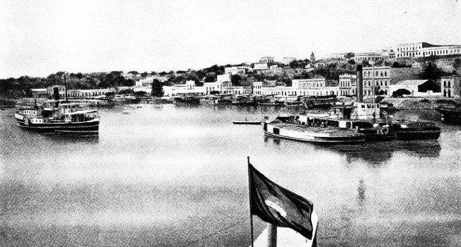
THE HIGHEST NAVIGABLE POINT to which power-
THE Rio de la Plata is the Spanish name of what is known to English-
Upon the muddy and almost tideless waters of the estuary float the fleets of meat and grain ships which ply to most parts of the world. Nearly all the meat ships and a proportion of the grain ships are also liners.
The rivers tap one of the chief food-
The estuary is formed by the junction of the Rivers Parana and Uruguay, the former having a mighty tributary, the Paraguay. These rivers and their tributaries form an intricate network of navigable waterways extending from Buenos Aires into the heart of Brazil and almost to the Andes in Bolivia. Some of the headwaters almost touch those of the River Amazon. The network is south of the ramifications of the Amazon and, although not so vast, is of much greater commercial value. The general direction is from north to south, and the waterways, in their lower reaches, are capable of taking ocean ships. Above these reaches the waterways are navigable for thousands of miles and are used by power-
The most easterly of the rivers of the system, the Uruguay, rises in Brazil, and after a course of many miles forms the boundary first between Brazil and Argentina, and then between Uruguay and Argentina. The next great river, the Parana, is formed by the confluence of the Rio Parana-
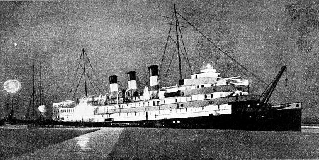
A NIGHT SCENE AT MONTEVIDEO. The Ciudad de Montevideo seen at the great river port and Uruguayan capital. This ship and her sister vessel, the Ciudad de Buenos Aires, are among the largest and most luxurious operating on the River Plate; they normally ply between the capitals of Uruguay and Argentina, Completed in 1915, the Ciudad de Montevideo was built at Birkenhead. She has a gross tonnage of 3,872, a length of 350 ft. 11 in., a beam of 44 ft. 2 in. and a depth of 13 ft. 5 in.
The River Paraguay flows down from the Matto Grosso district of Brazil and takes a southerly course to join the Parana above the town of Corrientes in Argentina. At Asuncion, the capital of Paraguay, it is joined by the Pilcomayo, and later by the Bermejo, both of which flow from the north-
So excellent are the communications by sea and river that the traveller can board a liner at a capital such as London or New York, go to Buenos Aires or Montevideo, and then transfer to a comfortable river vessel and proceed into the heart of South America. Cities such as Buenos Aires have altered out of recognition in the last half-
Development of the inland waterways, ocean shipping, docks and refrigeration are factors which have made the River Plate prosperous and have reduced the cost of meat and bread to millions of Europeans. Passenger liners elegant accommodation is designed to appeal to the taste of wealthy Spanish-
The first Europeans to enter the estuary were the Spaniards who sailed from Spain in 1515 under Juan de Solis to search for the way to India. De Solis was killed by Indians when he landed in what is now Uruguay. Some years later Sebastian Cabot sailed into the estuary and up the Parana to the Paraguay and founded unsuccessful settlements. On February 2, 1536, Pedro de Mendoza arrived with fourteen ships at the mouth of the Riachuelo (Little River) and founded the first city of Buenos Aires, but this settlement did not endure. The Spanish raided the natives for food and the natives retaliated in force.
Meanwhile, other Spaniards sailed up the Paraguay and founded Asuncion, 883 nautical miles above Buenos Aires, and the settlers afterwards forsook Buenos Aires for the new city of Asuncion, which became the capital of the Republic of Paraguay. In the early days it was the capital of the vast region known as the Rio de la Plata, which included what is now Argentina, Uruguay, Paraguay and part of Bolivia. Here resided a governor who was subordinate to the Viceroy of Peru, at Lima, in the Andes. Later a second city was founded at Santa Fe, on the River Parana, 318 nautical miles from Buenos Aires. The founder, Juan de Garay, went to the abandoned site of Buenos Aires in 1580, and made another and successful effort to build a town there.
Originally the Spaniards called the estuary the Mar Dulce, or Fresh-
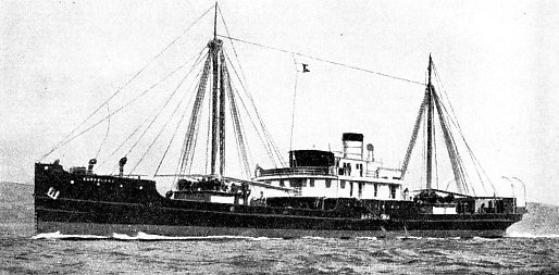
FOR CARGO SERVICE on the up-
Argentina, the richest and most prosperous of the River Plate republics, has Buenos Aires as its core and central port through which passes about two-
One of the old-
The fleet includes packet ships which maintain a nightly service between Buenos Aires and Montevideo, river vessels which serve inland ports, and freighters and tugs. South-
Montevideo, the capital of Uruguay, dates from 1726 and has a population of 667,200. It is much smaller and less cosmopolitan than Buenos Aires. The early settlers came from a different part of Spain. During the last century conditions in Uruguay were so upset by civil wars that the great tide of Italian emigrants preferred the Argentina side of the River Plate. Over considerable periods Italian immigrants outnumbered those from Spain, and Italian labour and British capital did much to build modern Argentina. The whole of the Uruguayan shore is higher than that of Argentina, which is flat and monotonous.
Although the general range of the tide is only 18 inches, the force and direction of the wind seriously affect the depth of water in the channels, the difference ranging from 6 to 14 feet. In consequence careful watch on the weather, which affects the depth, is kept at ail ports and the depth of water is indicated by signals. The River Plate is noted for sudden changes of weather. The pamperos, winds so named because they blow over the pampas, are dangerous to small craft.
Nearly all maritime countries send ships to the River Plate. During the immigration boom Italian ships secured much of this traffic from Mediterranean ports, although British liners had a
share of the traffic from the Atlantic ports of Spain. The Italian traffic was remarkable because thousands of Italians went to Argentina to reap the harvests or for sheep-
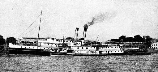
AT CORRIENTES, 652 miles above Buenos Aires, near the confluence of the Upper Parana and the Upper Paraguay Rivers. At the quay is the paddle steamer Washington, of 2,376 gross tons. Built in 1906 at Glasgow, she has a length of 320 feet a beam of 40 ft. 2 in. and a depth of 20 ft. 1 in. She belongs to the Argentine Navigation Company.
Competition for passenger traffic is keen, as wealthy Argentines spend their holidays in Europe, and there are many fine vessels on the route. The Cap Arcona, 27,561 tons, of the Hamburg South American Line, is the swiftest vessel. Among British companies that known as the Royal Mail Lines is noteworthy because its connexion with the River Plate goes back for about three-
The ranchers of the River Plate improved their herds by buying British pedigree cattle and sheep and breeding from them. The rapid growth in the demand for chilled beef altered the animal population of the pampas, leading to a great increase in the number of cattle. The River Plate is some 6,000 miles from Great Britain, or half the distance to Australia, and this difference in distance has been advantageously used by concentrating on the chilled beef trade. Until recent improvements in refrigeration were made, chilled beef could not be exported successfully from the Antipodes, although frozen mutton and iamb could stand the voyage. Argentine mutton and lamb are, however, an important export, as are wool and wheat, and almost the entire trade of the River Plate concerns stock-
A feature of the River Plate is that the major ports of Buenos Aires, Montevideo and La Plata are not the terminals of the entire ocean traffic, as many vessels go into the rivers. The two towns of Fray Bentos and Paysandu, on the Uruguay, which are reached by ocean ships, are famous for their meat-
Floods change the course of the river, forming islands of silt and branches which dam the'water and cause it to cut new channels. The Uruguay is entered above Carmelo, on the shore of the River Plate, and is about a mile wide. Then it widens and does not become narrow until above Fray Bentos. Below this town the River Negro, which is navigable by river vessels, flows into the Uruguay.
Paysandu, also on the Uruguayan shore, is usually the limit for ships drawing up to 14 feet, and is about 176 nautical miles from Buenos Aires. When the river is high vessels go up to Salto, about 220 miles from Buenos Aires, and opposite Concordia, in Argentina. There is sometimes a rise of 40 feet in the high-
The Parana enters the River Plate by several channels, and the rise and fall of the river is less than that of the Uruguay.
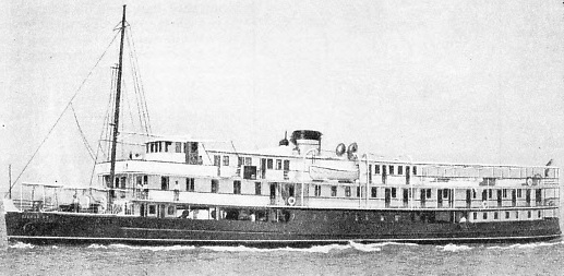
THE LUXURIOUS MOTOR VESSEL, Ciudad de Concepcion, which operates between Asuncion (Paraguay) and Corumba (Brazil). She is a splendid example of the river craft that work in this region. Her extensive superstructure, where there is spacious cabin accommodation, is largely made possible by the use of specially light steel. She was built at Glasgow in 1930 and has a gross tonnage of 900. Her length is 200 feet her beam 37 feet and her depth 8 feet.
Along the lower reaches are ports frequented by ocean ships, and one of these, Rosario, 203 nautical miles from the capital, has 500,000 inhabitants, and is reached by ships of 10,000 tons. It owes its importance mainly to its development as an ocean port. The town of Santa Fe, which is 318 miles from Buenos Aires, has docks for oceangoing ships. The River Iguassu flows
into the Parana from the east and is the boundary of the Misiones Territory of Argentina. The Iguassu forms one of the world’s great waterfalls some ten miles above its confluence with the Parana. Although the falls are over 1,000 miles by river from Buenos Aires comfortable river vessels carry tourists to see them. A river boat from Posadas links with the river services from the capital. The River Paraguay is navigable for the greater part of its course of 1,800 miles, and forms the main highway of the Republic of Paraguay Asuncion is 883 miles above Buenos Aires, with which it is linked by a service of river vessels. The river north of Asuncion is called the Upper Paraguay and is served by power craft which go to Corumba, the commercial centre of the Brazilian State of Matto Grosso and 1,618 miles from Buenos Aires. Even this is not the limit of navigation, as small craft go up the Cuyaba, a tributary, to Cuyaba. the capital of Matto Grosso.
 Although the power-
THE IMPORTANCE of the River Plate and its tributaries to the republics concerned can be judged from this map. The river system taps one of the chief food-
There are various types of motor freighters and steam vessels including paddle steamers and stern-
In addition to the large companies which run fleets of vessels from Buenos Aires and Montevideo up the rivers, there are local services, which operate as water-
Many cattle are taken by water to the establishments on the banks, where they become chilled meat, or corned beef and meat extract. Quebracho, a hardwood yielding tannin, much of which comes from the Chaco Territory, is sent down the river to the tanneries and is also exported. One company has two motor vessels especially for this river trade.
You can read more on “Ciudad de Buenos Aires”, “The Mighty Amazon” and “River Plate Cargo Ships” on this website.